February 14, 2015
Start: Picket Post TH (N 33° 16.334 W 111° 10.576).End: Montana Mountain Saddle, Passage 18, mile 16 (N 33° 24.177 W 111° 09.336).
Miles: ~16.
I woke up a little before six when someone drove into the trailhead parking area. After a few minutes lying there listening to them I figured I ought to get up myself. I was in the tent packing things up when they started riding their bikes up the trail towards Alamo Canyon with lights as it was still dark out. Another cyclist drove in shortly after they left but he got ready and waited for enough morning light to start.
Around 7:30 I was all packed and ready to start the hike. I turned on my GPSr. and went to see where the trail went. For some reason the tracks weren’t showing up, neither were all the waypoints for the trail. That was rather disconcerting as all I had for navigation at that point was the trail data sheet but it didn’t have any coordinates listed. I didn’t even have a paper map to look at. After fretting for a bit, I decided to just start hiking and hope the trail would be easy enough to follow; what else could I do?
 |
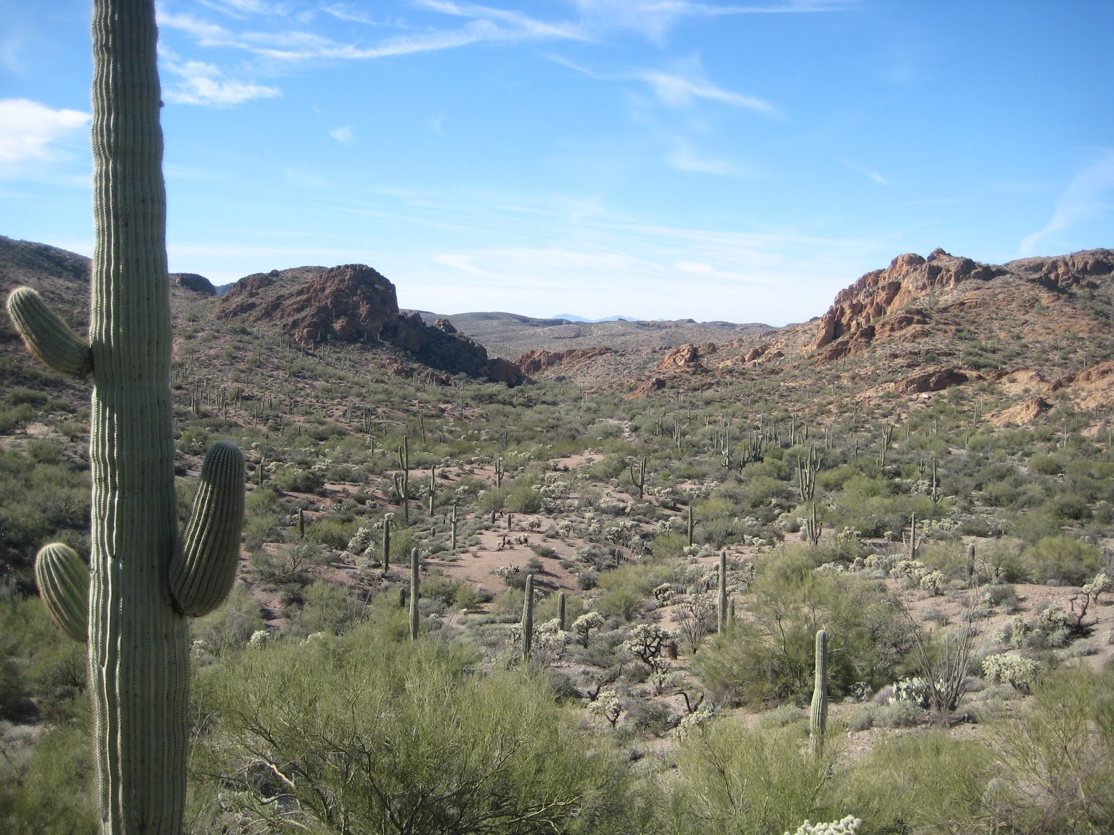
| Leaving Picket Post |
The trail was easy enough to follow, at least at the start. I followed the trail to where it crossed under highway 60 and continued on. After almost two miles, the trail crossed a road. I don’t know why, but for some reason I turned left on the road instead of crossing it and following the trail. After about a half mile along the road, I stopped at a road junction to unzip my pant leggings and put on sunscreen. Another third of a mile and I started having doubts that I was still on the AZT. Another tenth or so and I decided to see if there was enough cell service to get the waypoints off of the AZT website. I turned the phone on and barely had enough service to retrieve the waypoints for the two passages and save them on the phone. While doing this, a lady walked by and verified that I wasn’t on the trail and it was back the way I had come. I punched in a few of the waypoints to my GPSr, then started heading back the way I came. This cost me about an hour and ten minutes and 1.9 miles of walking but in the end it turned out to be a good thing because I now had the waypoints and was no longer worried about losing the trail.
Shortly after I was back on the trail, I crossed railroad tracks and followed the trail up along a finger of a ridge where there were good views of the mountains ahead. After around an hour the trail dropped down the end of the ridge and worked its way into Whitford Canyon. While crossing the wash I met six snowbirds that were out for the day, heading south. We chatted for a few minutes, then I continued for close to ten more minutes where I decided to stop and rest.


There was shade and green grass to enjoy while I rested. I had some food but mostly entered several trail waypoints into my GPSr to help me keep track of where I would be on the trail. After about an hour, when I was finishing up with that, the snowbirds passed by on the way back to their start. A minute later I was back on the trail and a few minutes later I caught up to them about the same time that a mountain biker converged with us. It’s interesting how groups of people tend to converge together on a trail for a minute and then separate again.
 |
| Whitford Canyon Rest Stop |
The trail continued up Whitford Canyon a short distance to where it crossed FR650 then paralleled the canyon to its west (the trail’s west). The trail passed by a windmill and water source that wasn’t in the data book. It is now.

Close to half past one, about an hour and a half after my last break, the trail dropped down to a road and crossed Whitford Canyon again. There was running water, so I stopped to rest and get some. It had been warm out and I had been drinking more than anticipated. It was a nice fifty minute break where I got to cool my feet in the water.

From there, the trail follows Reavis Trail Canyon for maybe three and a half miles to where the canyon ends and the trail turns up Montana Mountain. After several hundred feet of climbing, I was having trouble keeping any kind of pace up the hill and stopped for a rest. After some food and Gatorade, I felt much better and continued the slog up Montana Mountain. Along the climb there were a few places where the trail levelled out and there would have been good camping. I was very tempted to stop and call it a day, but I wanted to get to the top more. There was a nice level green spot just below the saddle, but the ground was all pitted from cattle, so I continued up to the saddle where I decided to set up camp for the night.

After pitching my tent and other chores, I made the short climb to the top of Montana Mountain where I attempted to find a survey mark. I looked around for several minutes but was unable to locate it. I’ve since found out that it’s buried under a couple inches of dirt. The sun set and then I headed back down to camp where I had dinner and then read for a while before turning out the light.
 |
| Sunset atop Montana Mountain |

February 15, 2015
Start: Montana Mountain Saddle, Passage 18, mile 16 (N 33° 24.177 W 111° 09.336).End: Passage 19, mile 11 (N 33° 31.531 W 111° 07.928).
Miles: ~13.6.
I thought it would get cold last night since I camped above 5400’, but it was actually really nice. I’m not sure what time I woke up, but I did enjoy a very nice sunrise. It always seems to take me too long to get up and break camp; this morning was no exception. I was finally on the trail past eight.
 |
| Sunrise |
Not far below where I camped, the trail joins FR650 and follows it to Roger’s Trough trailhead. The morning’s agenda was to find some geocaches along the way to the trailhead. The first geocache, Candy Shop Confusion-Dubble Smart, was down the road, in the opposite direction of the trail, so I dropped my pack to go find it. Twenty minutes later I had my pack back on and was heading in the right direction. Ten minutes after that, I dropped my pack to find the next geocache, Candy Shop Confusion-Smart Head. This cache was supposed to be hanging in a tree and I wasn’t able to find it but I did find the string it was tied to. I gave up and took an easier way back to the road when I found the cache on the ground. I ended up putting it next to the base of the tree then headed back to the road, where another backpacker was walking by. He stopped and we introduced ourselves and talked for a bit. Ron was from Portland, Oregon and was hiking the trail from Picket Post to Pine or Flagstaff. I mentioned I was going to find some geocaches along the way and maybe we’d see each other up the trail. He took off and I went around the corner to get my pack before continuing.
Five minutes later I dropped my pack once again to find geocache, Candy Shop Confusion-Tootsie Bubble. Once again the cache was supposed to be hanging in a tree. Once again I found a string in the tree but no cache. This time I wasn’t able to find the cache. The ground was fairly steep so there’s no telling how far or where the cache rolled to. I had better luck at the next geocache, Candy Shop Confusion-Head Roll, and then finished the day’s geocaching finding, Buena Vista de las Montanas.
From there it was a short walk to Roger’s Trough trailhead, the end of passage 18 and the start of passage 19. I was surprised to meet back up with Ron at the trailhead. We seemed to hit it off fairly well so we entered the Superstition Wilderness together at quarter past ten.
 |
| At Roger's Trough Trailhead |
We were chatting up a storm and the miles were passing by when we came to a couple hiking towards the trailhead with two standard poodles. One of the dogs had injured a foot the day before so it was in the man’s backpack. They cut their hike short yesterday hoping the dog’s foot would be better after some rest but it was still bad this morning so they were hiking out.
At half past eleven the trail climbed through some scrub and I was getting tired since I hadn’t had a real break all morning. There’d been a lot of stopping with the geocaching, but I hadn’t had a break and I was starting to drag. It felt good to sit down, take my boots off, and get some food in my belly. We were back on the trail a bit past noon.
After the break, the trail finished climbing and followed some meadows and there was a lot of tall grass. The hiking was really enjoyable and the trail followed Reavis Creek and went through Ponderosa. As we neared Reavis Ranch, there was an American Conservation Experience (ACE) trail crew attempting to move a large rock out of the trail. We talked for a couple minutes before continuing. I’m still trying to figure out why they didn’t just move the trail around the rock as that would surely have been much easier to do. It must be for the experience.

When we got to Reavis Ranch, we stopped for another half hour break. I looked around a little bit but not enough. I’ve heard so much about Reavis Ranch and didn’t take the time to explore it very much at all. I didn’t even find where the apple orchard was. Next time.
 |
| Looking South from Reavis Ranch at ACE Trail Crew |
 |
| Looking North from Reavis Ranch |
Maybe a third of a mile past Reavis Ranch, we turned right (east) onto another trail and soon crossed Reavis Creek. There was a man relaxing in a hammock there. He had a nice looking camp site. After the creek, the trail started climbing. A lot of brush had recently been cut back and the tread improved. Thank you ACE! Well, the climbing ended and turned into a descent when the recently maintained trail turned into a very rocky trail and the going slowed down.
 |
| Ron |
I don’t remember why, but Ron and I split up for a while on the descent. I think maybe Ron had to get something in his pack. Whatever it was we were hiking together again by the time the trail levelled out and then started climbing.

Around ten past four, we reached Walnut Spring and stopped to get water. Ron finished up getting water before I did and went down the trail a ways. He came back and had me guess what was up the trail a few hundred feet. An awesome camp site, that’s what. I was planning on hiking a few more miles but the trail crossed an 800’ canyon and having to walk down and up it with a full load of water didn’t appeal much to me at the time. That and it was already late enough in the day that an early stop seemed to be a good idea. It was a great place to camp with an awesome view of Four Peaks.
 |
| Four Peaks from Camp |
 |
| Looking South from Camp |
 |
| Camp |
February 16, 2015
Start: Passage 19, mile 11 (N 33° 31.531 W 111° 07.928).End: Vineyard TH.
Miles: ~17.7.
After a good night’s rest, I was able to get going more quickly this morning. Perhaps I moved quicker so Ron wouldn’t have to wait too long for me to break camp. We were on the trail at half past seven.
The trail started off with a gentle rise then plunged into a canyon below Two Bar Ridge. The descent was steep and difficult with very few switchbacks. Finally it started to contour around the canyon before starting a steep ascent on the other side. Not too far into the climb, the trail passed some Indian ruins. At least I believe the fallen rock walls were Indian ruins. I’m glad I spotted them as it was nice to take a couple minutes break to check them out before continuing the climb. Finally we crested the ridge and crossed a saddle where we stopped for a half hour break.
 |
| Four Peaks |
 |
| Ruins |
From there, the going was very slow as we traversed Two Bar Ridge. The trail curved around rocks and cactus and brush and there was no flow to it. It was difficult to keep and maintain any kind of stride. I mentioned to Ron to watch out for the Prickly Pear cactus, that the small spines were trouble, not the larger ones. What I meant really didn’t register with him until he found out the hard way. I let him use my Leatherman to help pull the spines out of his leg. Finally after about five miles for the day, the trail became much easier to walk. But just to spite us, the trail started another steep ascent. About half way up I ran out of gas and we stopped for a fifteen minute break. We’d been out for close to four hours and hadn’t even made six miles on the trail. If things didn’t improve, it was going to be a very long day.


Once we completed the climb, the trail improved and we were able to walk a normal pace. The trail contoured around Pinyon Mountain and I found a lighter on the trail. Not long after, we approached a gate at the wilderness boundary and there was a hiker there getting ready to light a cigarette. I asked him if he lost a lighter. He said yes and I handed it to him. We all hiked another mile as the trail descended steeply down some old roads. At the bottom, we took a short break under a tree regrouping.

 |
| Tip of Roosevelt Lake |
A mile farther down the trail, we came to a trick tank and stopped to eat and water up. The other hiker had left his trekking poles in Globe, so he decided to turn around and head down to the highway a different way than we were going. I don’t think we ever got his name.
After the trick tank, the trail followed Cottonwood Creek. It continuously crossed the creek or followed the rocky creek bed for near three miles. Again, this was slow going but parts were shaded in Cottonwoods and it was enjoyable walking. Near the end, in an open flat area we came to another trick tank that was long inoperable. I sat down on the edge and took a short break. A bit farther we crossed the creek were it had good flow and some pools and I stopped and rinsed my shirt and myself off before we continued.
 |
| Ron |
 |
| View From the Inoperable Trick Tank, Note the Pipe |
From there the trail climbed away from the creek onto a road. It climbed some and then made a steep descent, with great views of Roosevelt Lake, back down to where it crossed the creek. I made it down the hill before Ron so I stopped and waited there. There were trees and it was shaded so it was a nice place to rest for a half an hour. It was about ten past four when we started walking again.
 |
| Getting Closer to Roosevelt Lake |
After crossing the creek, the road climbed up around a bend and passed a corral. The road climbed gently for a bit before the trail branched off from it and followed a ridge down towards the lake. Just over a mile from our break, we came to the Cemetery Trail junction. Ron headed down that trail to resupply at the marina. There was also a geocache that way too, so I dropped my pack and went with Ron a bit farther where we said good bye. After a short search, I found geocache, Cemetery Trail 255, signed the log, and went back to my pack.
It was quarter of five and I had three miles left. I was tired from the long day of difficult trail. I was mildly concerned I’d finish up in the dark. I was hoping the rest of the trail would be easy. I wanted to rest some more. I had some drink and I figured I better just get walking. I hefted my pack and went. There was a sign that made me think that there would be less than three miles but that was on a different trail. The AZT wound around every which way, going in and out of drainages and up and down. Sometimes I think the trail builders are masochists. Either that or somebody wanted the AZT to be another hundred miles by adding silly back and forths. I kept plodding on. Somewhere I passed a new metal trough filled with water. It looked like a nice place to camp. Then the trail climbed again and crested a ridge where I could see the bridge across the water. From there the walking was mostly downhill but the trail still wound around working its way past several gullies. Finally there was a large metal trail sign and I climbed up onto highway 88.
It was nice to be on the pavement. Not because pavement is easy to walk on, but because I knew I was almost done. All I had left was to cross the bridge and get to the trailhead parking where my truck was waiting. It took longer to cross that bridge than I thought it would. There’s a fairly long run up and down to and from it. It is fun looking over the side of it towards the dam too. I was worried my hat would blow off so I held it for a lot of the time. Finally I made it to the other side and was done before sunset.
 |
| My Truck is on the Other Side |
 |
| All Done and Almost Sunset, Looking Back |