September 25, 2015
Camped: Below Montezuma Pass (N 31° 21.737 W 110° 18.026)I wasn’t sure if I’d be able to make this section of the hike. I had plans to hike it with a man I met on the Hike Arizona Website that was looking for someone to hike the first three passages with him. As far as I was concerned, everything was set, then yesterday, he bailed out because he was worried it would be too difficult to do with his level of fitness. He’s the one that suggested three days to complete it too. Fortunately I was able to set up a ride from Patagonia back to Montezuma Pass with Ken’s Shuttle Service.
Tonight, after dinner, I hopped in the truck and drove over Montezuma Pass and down the hill a ways, where I camped at a pull off just off FR61 below Eighty Spring. It was windy out but comfortable. I set up on the leeward side of the truck. The moon is almost full so I pulled my beanie over my eyes so I could sleep better.
September 26, 2015
Start: US/Mexico border monument 102.End: Sunnyside Canyon, Passage 1, mile 16.2 (N 31° 26.756 W 110° 23.330).
Miles: ~16.1.
After a reasonable night’s sleep, I got up and stowed my sleeping bag, pad, and cot quickly. I grabbed some food and started driving back up towards Montezuma pass. Along the way, I stopped and found geocache, San Rafael Vista. There’s some really nice views south into Mexico from it.
My plan was to head to the Coronado National Monument visitor center to get permission to park at Montezuma Pass. I got there early enough that I decided it would be best to hike down to the border and back first so I wouldn’t waste time waiting for it to open. After a few minutes getting my pack situated and taking a few pictures, it was quarter past seven and I was on my way.
It took me about forty minutes to make it to the border. The views along the way were spectacular. The day was clear and I could see miles into Mexico. The trail went along the side of a ridge with a drainage to the east where there was water seeping out of the rocks. I knew I was getting close to the border but it stayed hidden from view. I was very close when the border monument abruptly appeared, overwhelming me with emotion. I knew then that I would be completing the trail. This trip would fill the one gap in my progress and I already had the final stretch from Grand Canyon to Utah scheduled. I thought back to when I started last November and all the doubts I had about ever being able to complete the trail. Those doubts were now replaced with confidence. Now I just had this trip to hike and then one more in a month’s time.
 |
| Mexico |
 |
| Me at Border Monument 102. |
I spent about ten minutes at the border, savoring the moment, looking into Mexico, and taking some pictures before hefting my pack and climbing back up to Montezuma Pass. Once back at my truck, I talked to a couple of Border Patrol agents and asked if I needed a permit to park my truck in the lot for a few days. They said they didn’t care but the park may require one. I had cell service so instead of driving there, I decided to call and see if one was needed. The park service said to leave a note on my truck for law enforcement and that would be fine. I thought that was funny since the Border Patrol told me they didn’t care. At any rate, I was happy that I wouldn’t have to waste time driving to the visitor center and back.
 |
| Heading Back to Montezuma Pass |
From Montezuma Pass, the trail climbs into the Miller Peak Wilderness. It’s not a steep climb but it is long and tiring. After close to an hour, I passed a group of Asian hikers that I saw leave Montezuma Pass maybe forty minutes before I did. There were some adits along the trail that had been closed with heavy steel bars that I passed about the same time. I continued up the trail another forty minutes where I stopped to rest and eat. I figured the Asians must have turned around because I hadn’t seen or heard them during my break. Just when I was getting going again, after a half hour, they appeared down the hill from me. They were just hiking slowly.

 |
| Miller Peak |
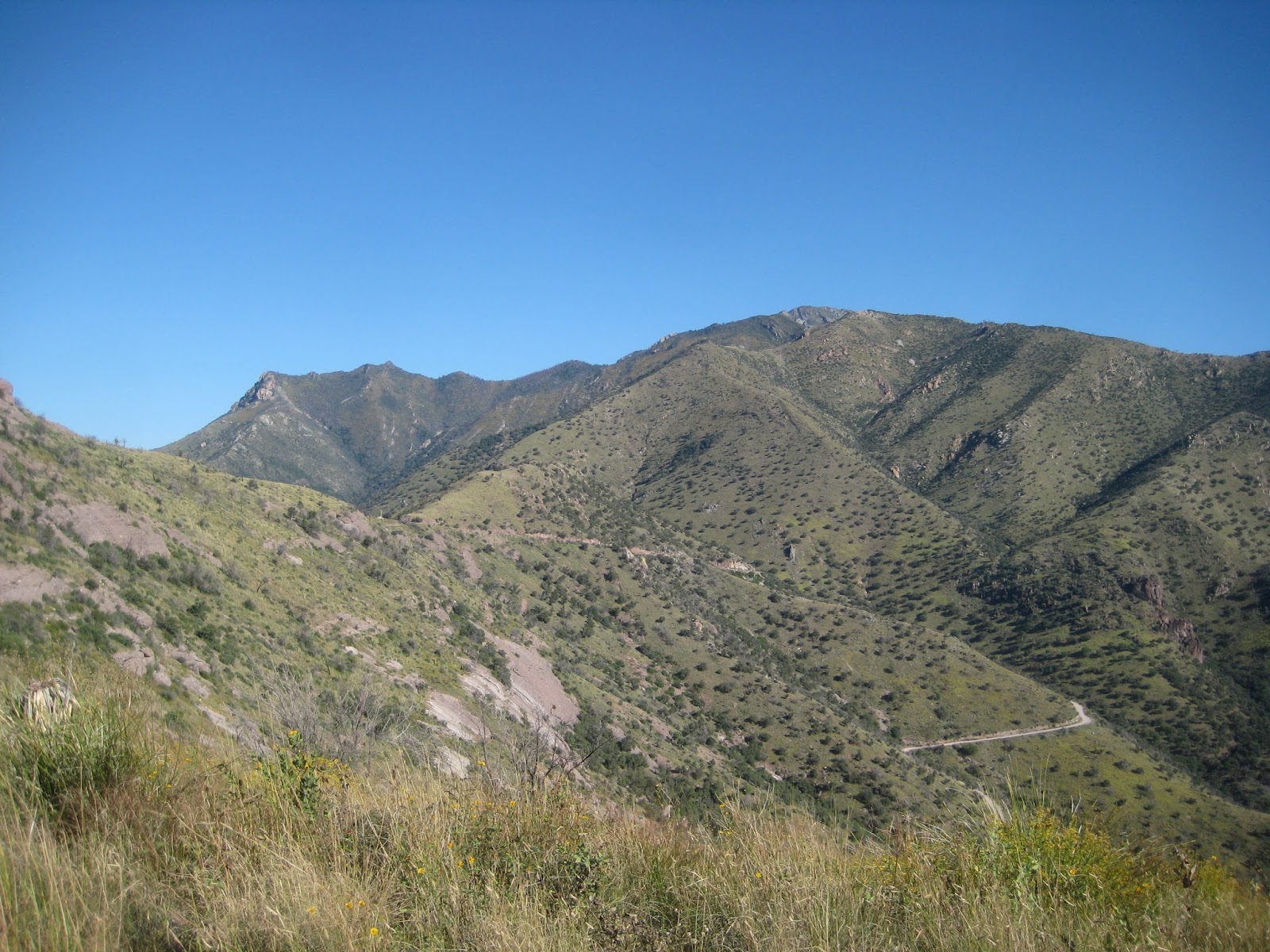
About quarter past noon, I reached the high point of the southern portion of the Arizona Trail at the junction to the summit of Miller Peak. I took it and continued another half mile and some 400’ to the top. The 360° views were incredible. To the northwest I could see over the Huachuca Mountains. To the north was Sierra Vista. I was 5000’ above the valley to the east and looking into Mexico was breathtaking. To the west, I was able to see Parker Lake and beyond, towards Patagonia. Miller Peak was the highest point I’d reach on the whole of my travels along the Arizona Trail and it was very much worth the detour to the top.
 |
| View to the NW Atop Miller Peak |
 |
| Back on the AZT Near Miller Peak Summit Junction |
I spent about a dozen minutes atop Miller Peak before heading back down. The whole side trip took just over forty minutes by the time I was back on the trail. From there, the trail continued down along a ridge and was easy hiking. At quarter of three, I reached Bathtub Spring where I took close to an hour break resting, eating, and refilling my water bottles.
 |
| Bathtub Spring |
About a half hour after I left Bathtub Spring, just past the junction to Bear Spring, I crossed a stream bed. I could hear running water but there was none across the trail. Surprisingly, just on the right of the trail was a large rock about waste high, and there was running water to the rock, but the water ran into the ground and under the trail. I found it very interesting.

From there, the trail went around a hill and then up onto a ridge where it meandered along. The hiking was very pleasant but I was tired and stopped for a half hour break just past four where the trail passed near where the mountain plunged into the valley. I picked a spot under a tree in shade with great view to the south. Even with the wonderful view into Mexico, most of the break was spent with my eyes closed.

Shortly after my break, the trail descends steeply into Sunnyside Canyon where a stream was flowing. I continued along until close to sunset where I found a place to set up camp for the night. It was so nice out I didn’t bother with the tarp and cowboy camped. In the canyon, twilight didn’t last long, so I ended up cooking and eating in the dark. Just before lying down for the night, I saw a pair of eyes about sixty yards off. They jumped around a bit then showed back up. I asked them if they were a coyote or a fox. I got no answer so I asked again. The eyes then turned away and ran off.
September 27, 2015
Start: Sunnyside Canyon, Passage 1, mile 16.2 (N 31° 26.756 W 110° 23.330).End: Canelo Pass TH.
Miles: ~20.0.
As dark came quickly in the canyon last night, light came slowly this morning. I slept well enough but was slow to rouse. I pulled some food out of my bag and ate it as I laid there thinking I should get moving. I finished eating and finally got things together.
The morning was brisk in the shade but not cold. I was comfortable when I started walking at ten past seven. Soon, the trail left the Miller Peak Wilderness and then turned out of Sunnyside Canyon and up to Scotia Canyon. The trail was nice through Scotia Canyon and passed by a couple of windmills before it crossed FR48 and turned up towards the end of the passage.

About quarter past nine, I made it to the Parker Canyon Lake trailhead. Though it was starting to get warm and I was ready for a break, I decided to continue a ways farther where geocache Arizona Trail at Parker Lake was hidden. Once near the cache, I dropped my pack to search for it. It took me several minutes to find. It really shouldn’t have and figure it must have been because I was hot and tired. After finding the cache, I found a little bit of shade and had some food, drink, and enjoyed a good rest.
 |
| Parker Canyon Lake |
Including the search, I was there for about an hour before I got back on the trail. From there, I hiked for about a half hour when I reached Parker Canyon and stopped to get some water. It was getting warm and I didn’t know what the water situation would be up the trail so I filled up and drank a bunch too.
For the next hour and a half it got warmer out and the trail went up and down, though mostly up. The trail worked its way through scrub and was exposed to the noon day sun. Somewhere along here I started using my umbrella and at quarter past one I had enough climbing and stopped to rest and recuperate. I sat in a juniper’s shade and ate a bit and had some Gatorade.
A bit before two, I was on the trail again. I finished the climb I stopped on, then the trail dropped into a canyon and descended for a while before another short climb where it joined a road that descended along a ridge. I’d been walking along the ridge for a bit when the border patrol drove up and stopped. We talked for a few minutes and they offered me some water. I knew there was water not far up the trail but it was hot and I was thirsty so I accepted. I was given a gallon jug and told to leave it on the side of the road and they would pick it up later. I filled up my bottles, drank a bunch, and poured some over my head. It felt great. There was maybe a quart left when I left.
 |
| Looking Back at Miller Peak |
Not far after the break, the trail turned on a different road and passed a stock tank that was full and another half hour the trail was in a small canyon with pools of running water. I stopped at one climbed in to rinse off and to cool down. It was very refreshing.
The trail continued down Middle Canyon a ways farther before climbing up a ridge onto the Canelo Hills. The sun was lowering and I felt good after rinsing off and had no trouble climbing; I felt good kept a strong pace up the ridge where I stopped and dropped my pack to find geocache, Canelo Vista. It was over the ridge and in some rocks but it didn’t take too long to find and I was rewarded with great views to the west.
Once back on the trail, there was also great views to the east where I could see back where I hiked throughout the day and yesterday to Miller Peak. It seemed so far away; too far away to have walked from there to here.
 |
| Another Look Back at Miller Peak |
I didn’t stay long because it was getting late and I wanted to finish the passage or at least drop down off of the east Canelo Hills. The trail skirted along the edge of the ridge gaining some elevation but the walking was easy. Then the trail dropped off the ridge to the north and descended fairly steeply. I could see some tanks below but the trail headed north of them. That didn’t matter anyway because I had plenty of water.

It was getting dark when I made it to the Canelo Pass trailhead. There was a great place to set up camp right there too. I was happy because I finished passage 2 before it was dark and didn’t have to search for a campsite. It was another nice night so I cowboy camped and was able to enjoy the blood moon and lunar eclipse.
September 28, 2015
Start: Canelo Pass TH.End: Patagonia Market.
Miles: ~16.6.
I got going about the same time I did yesterday morning at ten past seven. First I got a short distance down the trail when I decided to take a picture at the trailhead. After that, I got maybe a hundred yards down the trail when I realized I left my trekking poles hanging from a tree. Unfortunately, backtracking ended up being a common occurrence this day.

The trail started out easy and after maybe three fourths of a mile, I left the trail to climb a mountain and find geocache, Under a Spoon 15 Feet From Pass, last found almost five years ago. It was over 500’ of climbing to reach the top. It wasn’t a bad climb but it was fairly steep and I had to work my way through the junipers. The views from the top were well worth the effort, Meadow Valley stretched out before me in oranges and golds. After finding the cache and taking some pictures, I followed a ridge down the mountain and was back on the trail close to half past eight.


The trail dropped down to the top of Meadow Valley then skirted the hills. As I went along, the trail became more overgrown; a lot of grass had grown. Some of the trail had recently been brushed so that was easier walking, but where that ended, the trail was even more overgrown. At least I was able to follow it.
 |
| Freshly Brushed Trail |

About twenty past nine, I reached Down Under Tank where I stopped for about 45 minutes and refilled my water and had some food. Water was flowing down a creek below the tank where I gathered the water sitting in the shade.
 |
| Canelos Reflecting on Down Under Tank |
From there, the trail mostly followed old roads along Redrock Canyon and not two miles later I reached the Cott Tank Exclosure, a fenced riparian area. It was warm and I’d been drinking a lot of water, so I stopped and filled my empty bottles and drank what I could before continuing on.
Shortly after the exclosure, I passed the ruins of a stone cabin then saw some trail signs point across a creek and some more trail signs on the other side farther along. I saw no need to go where the first signs were so I went to the farther signs which turned up a road. After walking up the road a ways, I noticed I was off trail and it was back where I had come from, where the earlier signs had pointed. I still don’t understand what the sign I followed is for other than confusing hikers.
 |
| Stone Cabin |
I made my way back to the trail, where it continued down Redrock Canyon. I wasn’t really able to follow the trail through here. I lost it several times and mostly just worked my way down the creek bed. It was very frustrating not being able to find nor follow the trail. I was not sure what I would have done without the trail’s tracks on the GPSr. I’d find the trail and then it would just disappear in the grass. With all the grass, any cairns that may have been around were not visible. The grass even blocked the view of most of the trail signs along the way.
 |
| Trail? |
At half past noon, I found the first stage of geocache, Ashburn Mountain. The actual cache is somewhere at the top of the mountain. I was hot and tired and wasn’t nearly as far along as I planned to be so I skipped it and continued hiking for another fifteen minutes where the trail dropped back into the canyon and there was a nice sandy spot under some shady trees to rest. I spent a lot of time cleaning all the pointy grass seeds out of my socks. They are barbed so they can’t just be pulled out, but need to be pushed through. My gaiters keep a lot out, but they still work their way through the shoe. Anyhow, it was a big problem with today’s trail conditions.
The trail continued to be overgrown and hard to follow, however after a time I passed through a gate and the trail was immediately clear. Cattle must have been allowed to graze on one side of the fence, but not the other. Once again, there was grass poking my feet, so I stopped for a few minutes to clean the grass out of my shoes and socks, then continued. A short distance after that, I came to some water so I had another short break and filled a bottle.
After the water break, I had a couple false starts figuring out where the trail continued on the other side of the creek, where it then climbed up a hill. About twenty minutes later, at quarter after three, the batteries in my GPSr died. I wasn’t able to find my spare batteries and with the difficulty I had been having navigating, I decided to use the batteries in my SPOT. After the battery search, exchange, and some food, I was back on the trail.
At four, I reached a gate with rocks all over it where the trail started to drop to Harshaw Road around four miles from my finish. I turned my phone on and texted the shuttle service that I would be in town in about an hour and a half and continued on. The trail drops fairly steeply for a short distance then continues its descent to Harshaw Road. It’s about a three mile walk along Harshaw Road into Patagonia. About halfway through the road walk, I was running out of energy so I stopped and mixed up a Gatorade and sucked it down. The break and sugars really helped me out and I felt much rejuvenated for the last bit of walking. As I was nearing the end, Ken, from Ken’s Shuttle Service, pulled up and we introduced ourselves. He suggested I finish at the Patagonia Market and that he’d be waiting there. Perfect! I made it there at quarter of six.
 |
| Gate |
After getting some food and drink at the market, Ken drove me back to my truck at Montezuma Pass. We had really great conversation along the way and I really enjoyed the ride. Right as we were nearing the parking lot at Montezuma Pass, a rattlesnake was in the road. We stopped and got out and checked it out in his jeep’s headlights. I’m not sure what kind of rattler it was.
No comments:
Post a Comment