Tuesday, March 10, 2015

Arizona Trail, Roosevelt Lake to Sunflower

March 6, 2015

Start: Vineyard TH.
End: Passage 20, mile 11.75 (N 33° 40.056 W 111° 17.297).
Miles: ~11.75.

We left home this morning and made the drive to the Bushnell Tanks Road, just off the Beeline Highway near Sunflower. I drove the truck and Barbara and Katie followed me in the car. I parked and locked up the truck then hopped in the car and we drove to the Vineyard trailhead near the Roosevelt Lake dam. Once at the trailhead, I put on my boots and got everything ready to go. There were good bye hugs and I was on the trail around half past ten.


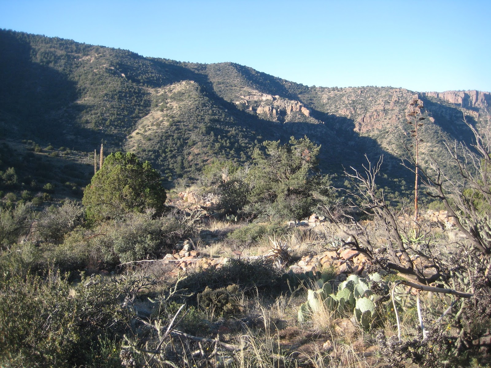
The trail started out steep, climbing over a thousand feet in the first mile and a half. I stopped frequently to check out the views of Four Peaks, the lake, and also of the dam when it was visible. After that initial climb, the trail leveled out some and even descended a short time where there was a man sitting on a rock waiting for some other hikers out ahead of me. There was a nice view of Apache Lake from where he sat.


Not far after that, I found geocache, Vinyamar in Nevrast. While enjoying the view from the geocache, I noticed three backpackers not too far ahead on the trail. Not twenty minutes later I had caught up to them. They all had large heavy looking packs on and weren’t moving very fast. They stopped for a break and I continued on. Maybe ten minutes later, while crossing a scree field I met two other hikers sitting down taking a break. They were out for the day and had completed section hiking the Arizona Trail last year. A half hour later at around half past noon, the trail followed a road for a short distance before turning up a ridge where I was ready for my own forty minute break and stopped for lunch.

Three Backpackers

Apache Lake

Close to half an hour of hiking along the ridge, I stopped to find geocache, Mogget. There were some poppies in bloom in the area too, along with great views all around. A bit past two, I reached the Mills Ridge trailhead where there was a couple on quads enjoying the view and hoping to spot some deer. We chatted for a minute, then I dropped my pack and found geocache, Mills Ridge Trailhead.

Poppies

Past the trailhead, the trail starts climbing again for over a mile before descending to Buckhorn Creek where I stopped to rest and filter some water. I spent about an hour at the creek before I got back on the trail around four. My pack was heavy with a full complement of water as the trail turned sharply up hill. As I climbed I heard whoops and hollers from across the canyon, where the three backpackers I had seen earlier were just starting to descend to Buckhorn Creek.

Buckhorn Creek

Eventually the trail entered the Four Peaks Wilderness and levelled out some near dry Hackberry Creek. I passed by Granite Spring where the spring box was damp but there was no water in it. From there the trail gently gained elevation as it contoured around some ridges. I could see that the trail crossed over a small saddle up ahead so I was hoping there would be a flat place to camp there as I was running short on day light. The saddle was fairly thick with brush around the trail, but there was a flat area just large enough to set up camp with a nice view of Roosevelt Lake and the sunset.


Today was a tough day. I was a bit shy of twelve miles but I camped about 3500’ above where I started. I was tired but content. After setting up camp, I watched the sun set then had dinner. I read for a while then turned out the lights.

March 7, 2015

Start: Passage 20, mile 11.75 (N 33° 40.056 W 111° 17.297).
End: Passage 21, mile 9.3, Pine Flats (N 33° 47.496 W 111° 23.288).
Miles: ~17.05.

I was up a bit after six but it was close to eight before I was on the trail. I took my time breaking camp by watching the sunrise over Roosevelt Lake and watching the sun light the Four Peaks as it got higher in the sky.

Sunrise over Roosevelt Lake

Moon and Early Morning on Four Peaks

Breaking Camp

Shortly after I started, the trail crossed the Chillicut trail which was very overgrown. I was glad I wasn’t turning down it. When I reached the Alder Saddle trail junction there was a lot of water flowing down the wash. There was water flowing down most every drainage I passed today and I hiked for miles with the sound of running water.

Four Peaks

At Alder Saddle Junction

Alder Creek

Shortly after I passed the Oak Flat trail junction, stopped for a 55 minute break. I was just entering a burn area. Apparently there is vehicle access to Oak Flat below because I could hear vehicles driving. Also, shortly after I stopped, I heard some talking and a couple hiked up the trail and turned onto the trail I had just come from.

Shortly after my break, I reached a camping area near Shake Spring. I wished I took my break here instead as it was next to the creek and was very nice.  From there the trail went in and out of the burn area. I’m not sure when the fire was, perhaps the year before.

Burn

It was noon when I reached Pigeon Spring trailhead, the end of passage 20. From there, passage 21, Pine Mountain, follows roads for over eleven miles. So road walking it was for the rest of the day. The first road was busy as there were a lot of ATVs going by. It was already warm out in the sun and the dust didn’t help either. In the future, I think I’d schedule this section for any other day of the week than Saturday.

Pigeon Spring Trailhead

After two miles of road walking, I came to a junction. The trail went to the left and there was a geocache down the road a ways to the right. I was debating whether to drop my pack or not when I lady pulled up and asked if I was hiking the Arizona Trail. She was planning on day hiking this passage tomorrow. Neither of us knew what the water situation was ahead, so she graciously gave me all the water I wanted. I think I took about a half-gallon. It turns out I didn’t need it but I felt good to get it. We talked for a few minutes and then she went on her way. I hid my pack then went and found geocache, Crozwell UFO crash site #2. Once I got back to my pack, I took my boots and socks off and ate some food and relaxed for a time.

It was almost two when I was finally walking again. More road. There ended up being little streams of water crossing the road quite frequently. I certainly didn’t need to be carrying all the water I had but I didn’t feel like dumping any out either. I knew it was getting cooler too, especially when I went around a shaded bend in the road with ice.


Looking Back To Four Peaks

I’d been walking almost two hours when I dropped my pack to find geocache, Jolene Mine. I had to descend a steep rutted road to get to it. Once I was back at my pack, I stopped for about ten minutes have a bite to eat before continuing at quarter past four.

Not far after that, I stopped to find another geocache, Arizona Trail: In the Mazatzal's. There wasn’t good access to it the way I tried, so I went farther along and there was an old road that went right to it.

At ten of five, I came to Little Pine Flat where there was a good stream flowing across the road. I decided to fill up on water there for the night’s camp, then look for a place to camp. Not much farther after getting the water, I found a nice campsite where I set my tent up maybe five feet from a running stream. Oh well.

Before setting up camp, I decided to find geocache, on the arizona trail as it was only a few hundred feet from camp. I had to climb over some trees and cross the stream to get to it. That was fun. Once back, I finished setting up camp and had dinner. Then I relaxed for the evening and read some. It was a good day.


March 8, 2015

Start: Passage 21, mile 9.3, Pine Flats (N 33° 47.496 W 111° 23.288).
End: Bushnell Tanks Parking.
Miles: ~10.5.

Someday I’ll figure out how to break camp more quickly. I was on the trail at eight and maybe five minutes later I thought I had left my camera back at the campsite. I dropped my pack and was starting to head back when I found it in my pants’ pocket. At least I hadn’t gone far before I found it.

At quarter of nine, I reached where the trail finally turned off the road and back to single track. Of course, I wasn’t done with the road yet, so I dropped my pack and continued down the road to find geocache, The Kings Playground. It was over half an hour later before I was back on trail enjoying the single track. The trail descended into a canyon and followed a flowing Boulder Creek. At ten, the trail crossed the creek and I stopped for a break. I took my boots and socks off and washed off in the creek, rinsing my shirt. After fifty minutes I started hiking again but almost immediately had to stop to change the batteries in my GPSr.


Break on Boulder Creek

The trail continued to follow Boulder Creek and I continued to enjoy listening to the running water. The trail would move above the creek bed and some points were overgrown with grass and it was hard to follow the trail. Eventually the creek turned away from the trail and the trail passed a road where several old cars had been dumped. Not a mile after that, at twenty of one, I reached Sycamore Creek.

Nice Pool

There's the Trail

Junk Yard

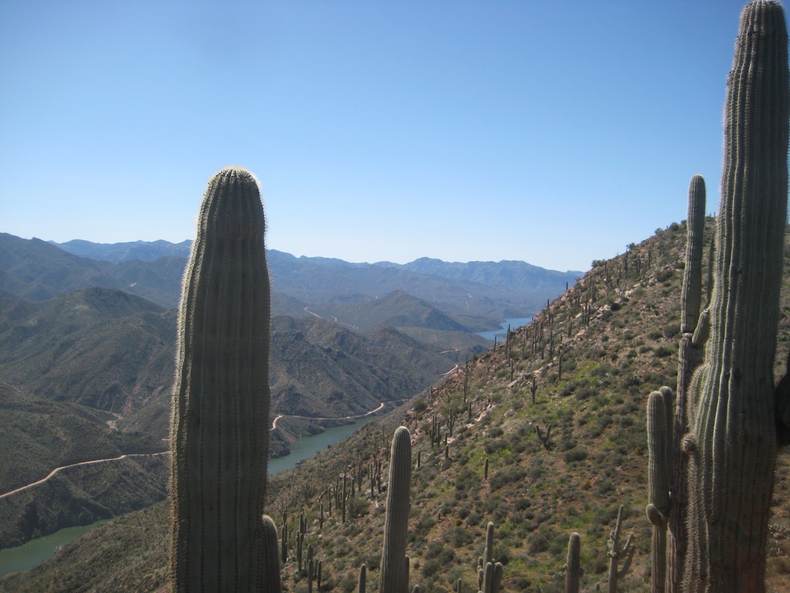
I crossed the creek and stopped under a large Sycamore tree to eat and filter some water. My plan was to find geocache, Bushnell Tanks. I’d been meaning to find it for years and this seemed like a good time. It was a few miles away so I hung my pack, grabbed a bottle of water, and took off. I had to follow the creek upstream for a while before I reached a road that I followed to the tanks. Bushnell Tanks is a large water tank with many troughs. It was used by the sheep herders and is no longer operable. It was interesting to check out. After finding the geocache, I checked out an old corral I passed on the way there. Near Sycamore Creek, there was a very lush area that is or was popular for camping. I stumbled upon an old latrine, a memorial, and some mechanical targets.


Bushnell Tank

Corral

Where's the TP?

Memorial

Spinning Target Art

When I got back to my pack, I filtered some more water to last me the rest of the hike and got back on trail. As I was leaving the Sycamore Creek area, I passed a family enjoying the water. From there the trail climbs some and contours around a hill. I could see the road I followed to Bushnell tanks off to my right. It was warm along here, away from the water, so I was glad it was only about a mile and a half to the trail junction to get to my truck. When I reached the junction I didn’t turn towards my truck, instead I turned towards the end of the passage, maybe a third of a mile farther.


Beeline

It was a bit past four when I reached the end of the passage, a tunnel under the Beeline Highway. I had a mini celebration when I got there, then turned around and headed back to my truck. This time, when I reached the trail junction, I went towards the truck, down and across Sycamore Creek. The trail was a bit confusing across the creek and I took a few missteps but I figured it out. Finally I was back on the Bushnell Tanks Road. I passed an Arizona Trail equipment trailer in a parking area. When I was nearly to my truck, I dropped my pack to find one more geocache, Opjim's Request: Along the Beeline. I had looked for it a couple years earlier but didn’t find it. Today I lucked out and found it fairly quickly.

Another Passage in the Books!

There was a gal in a car at the gate. When I reached my truck she got out of the car and took her dog on the other side of the gate. After I left, I thought she was probably Sandy’s daughter waiting for Sandy to finish her day hike. I wished I’d said hi and asked.

Friday, February 20, 2015

Arizona Trail, Picket Post to Roosevelt Lake

February 14, 2015

Start: Picket Post TH (N 33° 16.334 W 111° 10.576).
End: Montana Mountain Saddle, Passage 18, mile 16 (N 33° 24.177 W 111° 09.336).
Miles: ~16.

I woke up a little before six when someone drove into the trailhead parking area. After a few minutes lying there listening to them I figured I ought to get up myself. I was in the tent packing things up when they started riding their bikes up the trail towards Alamo Canyon with lights as it was still dark out. Another cyclist drove in shortly after they left but he got ready and waited for enough morning light to start.

Around 7:30 I was all packed and ready to start the hike. I turned on my GPSr. and went to see where the trail went. For some reason the tracks weren’t showing up, neither were all the waypoints for the trail. That was rather disconcerting as all I had for navigation at that point was the trail data sheet but it didn’t have any coordinates listed. I didn’t even have a paper map to look at. After fretting for a bit, I decided to just start hiking and hope the trail would be easy enough to follow; what else could I do?

Leaving Picket Post

The trail was easy enough to follow, at least at the start. I followed the trail to where it crossed under highway 60 and continued on. After almost two miles, the trail crossed a road. I don’t know why, but for some reason I turned left on the road instead of crossing it and following the trail. After about a half mile along the road, I stopped at a road junction to unzip my pant leggings and put on sunscreen. Another third of a mile and I started having doubts that I was still on the AZT. Another tenth or so and I decided to see if there was enough cell service to get the waypoints off of the AZT website. I turned the phone on and barely had enough service to retrieve the waypoints for the two passages and save them on the phone. While doing this, a lady walked by and verified that I wasn’t on the trail and it was back the way I had come. I punched in a few of the waypoints to my GPSr, then started heading back the way I came. This cost me about an hour and ten minutes and 1.9 miles of walking but in the end it turned out to be a good thing because I now had the waypoints and was no longer worried about losing the trail.

Shortly after I was back on the trail, I crossed railroad tracks and followed the trail up along a finger of a ridge where there were good views of the mountains ahead. After around an hour the trail dropped down the end of the ridge and worked its way into Whitford Canyon. While crossing the wash I met six snowbirds that were out for the day, heading south. We chatted for a few minutes, then I continued for close to ten more minutes where I decided to stop and rest.


There was shade and green grass to enjoy while I rested. I had some food but mostly entered several trail waypoints into my GPSr to help me keep track of where I would be on the trail. After about an hour, when I was finishing up with that, the snowbirds passed by on the way back to their start. A minute later I was back on the trail and a few minutes later I caught up to them about the same time that a mountain biker converged with us. It’s interesting how groups of people tend to converge together on a trail for a minute and then separate again.

Whitford Canyon Rest Stop

The trail continued up Whitford Canyon a short distance to where it crossed FR650 then paralleled the canyon to its west (the trail’s west). The trail passed by a windmill and water source that wasn’t in the data book. It is now.


Close to half past one, about an hour and a half after my last break, the trail dropped down to a road and crossed Whitford Canyon again. There was running water, so I stopped to rest and get some. It had been warm out and I had been drinking more than anticipated. It was a nice fifty minute break where I got to cool my feet in the water.


From there, the trail follows Reavis Trail Canyon for maybe three and a half miles to where the canyon ends and the trail turns up Montana Mountain. After several hundred feet of climbing, I was having trouble keeping any kind of pace up the hill and stopped for a rest. After some food and Gatorade, I felt much better and continued the slog up Montana Mountain. Along the climb there were a few places where the trail levelled out and there would have been good camping. I was very tempted to stop and call it a day, but I wanted to get to the top more. There was a nice level green spot just below the saddle, but the ground was all pitted from cattle, so I continued up to the saddle where I decided to set up camp for the night.


After pitching my tent and other chores, I made the short climb to the top of Montana Mountain where I attempted to find a survey mark. I looked around for several minutes but was unable to locate it. I’ve since found out that it’s buried under a couple inches of dirt. The sun set and then I headed back down to camp where I had dinner and then read for a while before turning out the light.


Sunset atop Montana Mountain


February 15, 2015

Start: Montana Mountain Saddle, Passage 18, mile 16 (N 33° 24.177 W 111° 09.336).
End: Passage 19, mile 11 (N 33° 31.531 W 111° 07.928).
Miles: ~13.6.

I thought it would get cold last night since I camped above 5400’, but it was actually really nice. I’m not sure what time I woke up, but I did enjoy a very nice sunrise. It always seems to take me too long to get up and break camp; this morning was no exception. I was finally on the trail past eight.

Sunrise

Not far below where I camped, the trail joins FR650 and follows it to Roger’s Trough trailhead. The morning’s agenda was to find some geocaches along the way to the trailhead. The first geocache, Candy Shop Confusion-Dubble Smart, was down the road, in the opposite direction of the trail, so I dropped my pack to go find it. Twenty minutes later I had my pack back on and was heading in the right direction. Ten minutes after that, I dropped my pack to find the next geocache, Candy Shop Confusion-Smart Head. This cache was supposed to be hanging in a tree and I wasn’t able to find it but I did find the string it was tied to. I gave up and took an easier way back to the road when I found the cache on the ground. I ended up putting it next to the base of the tree then headed back to the road, where another backpacker was walking by. He stopped and we introduced ourselves and talked for a bit. Ron was from Portland, Oregon and was hiking the trail from Picket Post to Pine or Flagstaff. I mentioned I was going to find some geocaches along the way and maybe we’d see each other up the trail. He took off and I went around the corner to get my pack before continuing.

Five minutes later I dropped my pack once again to find geocache, Candy Shop Confusion-Tootsie Bubble. Once again the cache was supposed to be hanging in a tree. Once again I found a string in the tree but no cache. This time I wasn’t able to find the cache. The ground was fairly steep so there’s no telling how far or where the cache rolled to. I had better luck at the next geocache, Candy Shop Confusion-Head Roll, and then finished the day’s geocaching finding, Buena Vista de las Montanas.

From there it was a short walk to Roger’s Trough trailhead, the end of passage 18 and the start of passage 19. I was surprised to meet back up with Ron at the trailhead. We seemed to hit it off fairly well so we entered the Superstition Wilderness together at quarter past ten.

At Roger's Trough Trailhead

We were chatting up a storm and the miles were passing by when we came to a couple hiking towards the trailhead with two standard poodles. One of the dogs had injured a foot the day before so it was in the man’s backpack. They cut their hike short yesterday hoping the dog’s foot would be better after some rest but it was still bad this morning so they were hiking out.

At half past eleven the trail climbed through some scrub and I was getting tired since I hadn’t had a real break all morning. There’d been a lot of stopping with the geocaching, but I hadn’t had a break and I was starting to drag. It felt good to sit down, take my boots off, and get some food in my belly. We were back on the trail a bit past noon.

After the break, the trail finished climbing and followed some meadows and there was a lot of tall grass. The hiking was really enjoyable and the trail followed Reavis Creek and went through Ponderosa. As we neared Reavis Ranch, there was an American Conservation Experience (ACE) trail crew attempting to move a large rock out of the trail. We talked for a couple minutes before continuing. I’m still trying to figure out why they didn’t just move the trail around the rock as that would surely have been much easier to do. It must be for the experience.


When we got to Reavis Ranch, we stopped for another half hour break. I looked around a little bit but not enough. I’ve heard so much about Reavis Ranch and didn’t take the time to explore it very much at all. I didn’t even find where the apple orchard was. Next time.

Looking South from Reavis Ranch at ACE Trail Crew

Looking North from Reavis Ranch

Maybe a third of a mile past Reavis Ranch, we turned right (east) onto another trail and soon crossed Reavis Creek. There was a man relaxing in a hammock there. He had a nice looking camp site. After the creek, the trail started climbing. A lot of brush had recently been cut back and the tread improved. Thank you ACE! Well, the climbing ended and turned into a descent when the recently maintained trail turned into a very rocky trail and the going slowed down.

Ron

I don’t remember why, but Ron and I split up for a while on the descent. I think maybe Ron had to get something in his pack. Whatever it was we were hiking together again by the time the trail levelled out and then started climbing.


Around ten past four, we reached Walnut Spring and stopped to get water. Ron finished up getting water before I did and went down the trail a ways. He came back and had me guess what was up the trail a few hundred feet. An awesome camp site, that’s what. I was planning on hiking a few more miles but the trail crossed an 800’ canyon and having to walk down and up it with a full load of water didn’t appeal much to me at the time. That and it was already late enough in the day that an early stop seemed to be a good idea. It was a great place to camp with an awesome view of Four Peaks.

Four Peaks from Camp

Looking South from Camp

Camp

February 16, 2015

Start: Passage 19, mile 11 (N 33° 31.531 W 111° 07.928).
End: Vineyard TH.
Miles: ~17.7.

After a good night’s rest, I was able to get going more quickly this morning. Perhaps I moved quicker so Ron wouldn’t have to wait too long for me to break camp. We were on the trail at half past seven.

The trail started off with a gentle rise then plunged into a canyon below Two Bar Ridge. The descent was steep and difficult with very few switchbacks. Finally it started to contour around the canyon before starting a steep ascent on the other side. Not too far into the climb, the trail passed some Indian ruins. At least I believe the fallen rock walls were Indian ruins. I’m glad I spotted them as it was nice to take a couple minutes break to check them out before continuing the climb. Finally we crested the ridge and crossed a saddle where we stopped for a half hour break.

Four Peaks

Ruins

From there, the going was very slow as we traversed Two Bar Ridge. The trail curved around rocks and cactus and brush and there was no flow to it. It was difficult to keep and maintain any kind of stride. I mentioned to Ron to watch out for the Prickly Pear cactus, that the small spines were trouble, not the larger ones. What I meant really didn’t register with him until he found out the hard way. I let him use my Leatherman to help pull the spines out of his leg. Finally after about five miles for the day, the trail became much easier to walk. But just to spite us, the trail started another steep ascent. About half way up I ran out of gas and we stopped for a fifteen minute break. We’d been out for close to four hours and hadn’t even made six miles on the trail. If things didn’t improve, it was going to be a very long day.


Once we completed the climb, the trail improved and we were able to walk a normal pace. The trail contoured around Pinyon Mountain and I found a lighter on the trail. Not long after, we approached a gate at the wilderness boundary and there was a hiker there getting ready to light a cigarette. I asked him if he lost a lighter. He said yes and I handed it to him. We all hiked another mile as the trail descended steeply down some old roads. At the bottom, we took a short break under a tree regrouping.


Tip of Roosevelt Lake

A mile farther down the trail, we came to a trick tank and stopped to eat and water up. The other hiker had left his trekking poles in Globe, so he decided to turn around and head down to the highway a different way than we were going. I don’t think we ever got his name.

After the trick tank, the trail followed Cottonwood Creek. It continuously crossed the creek or followed the rocky creek bed for near three miles. Again, this was slow going but parts were shaded in Cottonwoods and it was enjoyable walking. Near the end, in an open flat area we came to another trick tank that was long inoperable. I sat down on the edge and took a short break. A bit farther we crossed the creek were it had good flow and some pools and I stopped and rinsed my shirt and myself off before we continued.

Ron

View From the Inoperable Trick Tank, Note the Pipe

From there the trail climbed away from the creek onto a road. It climbed some and then made a steep descent, with great views of Roosevelt Lake, back down to where it crossed the creek. I made it down the hill before Ron so I stopped and waited there. There were trees and it was shaded so it was a nice place to rest for a half an hour. It was about ten past four when we started walking again.

Getting Closer to Roosevelt Lake

After crossing the creek, the road climbed up around a bend and passed a corral. The road climbed gently for a bit before the trail branched off from it and followed a ridge down towards the lake. Just over a mile from our break, we came to the Cemetery Trail junction. Ron headed down that trail to resupply at the marina. There was also a geocache that way too, so I dropped my pack and went with Ron a bit farther where we said good bye. After a short search, I found geocache, Cemetery Trail 255, signed the log, and went back to my pack.

It was quarter of five and I had three miles left. I was tired from the long day of difficult trail. I was mildly concerned I’d finish up in the dark. I was hoping the rest of the trail would be easy. I wanted to rest some more. I had some drink and I figured I better just get walking. I hefted my pack and went. There was a sign that made me think that there would be less than three miles but that was on a different trail. The AZT wound around every which way, going in and out of drainages and up and down. Sometimes I think the trail builders are masochists. Either that or somebody wanted the AZT to be another hundred miles by adding silly back and forths. I kept plodding on. Somewhere I passed a new metal trough filled with water. It looked like a nice place to camp. Then the trail climbed again and crested a ridge where I could see the bridge across the water. From there the walking was mostly downhill but the trail still wound around working its way past several gullies. Finally there was a large metal trail sign and I climbed up onto highway 88.

It was nice to be on the pavement. Not because pavement is easy to walk on, but because I knew I was almost done. All I had left was to cross the bridge and get to the trailhead parking where my truck was waiting. It took longer to cross that bridge than I thought it would. There’s a fairly long run up and down to and from it. It is fun looking over the side of it towards the dam too. I was worried my hat would blow off so I held it for a lot of the time. Finally I made it to the other side and was done before sunset.

My Truck is on the Other Side

All Done and Almost Sunset, Looking Back